
Wind gusts up to 40 to 45mph can be expected for most of Monday, with the strongest winds north of I-80. Temperatures will drop into the mid and upper 40s this morning as the colder air spreads across the state along with the cloudy skies and gusty winds. Interactive Radar | Weather AlertsAfternoon highs will only reach the upper 50s to around 60 degrees, nearly 20 degrees cooler than what we saw yesterday. After 3pm, a few spotty showers will start to pop up over far northern and northwest Iowa, then spread into central Iowa by the late afternoon hours. The chance for a spotty shower or isolated thunderstorm should reach the Des Moines metro by 5 or 6pm. Any rain won’t last long and shouldn’t amount to much, but you could run into a brief downpour or two, with the rain drying up by 10pm. Skies should clear out overnight, though the breezy conditions will continue with lows falling into the mid-30s.Sunny skies return on Tuesday, but the windy weather will continue with northwest wins of 20 to 30mph. Morning temperatures in the 30s will warm back into the upper 50s to around 60 degrees by the afternoon, slightly below average for mid-April. Winds will flip around to the south on Wednesday and stay gusty, but temperatures should warm into the 70s by Wednesday afternoon.A storm system will move into the Midwest on Thursday bringing rain chances as early as before sunrise on Thursday. Scattered thunderstorms are expected Thursday afternoon, and a few could be on the strong side. Gusty winds will continue on Thursday as well with highs in the 70s. Winds flip back to the northwest on Friday, staying gusty and pulling in more cooler conditions heading into the weekend.Des Moines ForecastToday: Clouds early, then sunnier toward midday. A spotty shower or storm after 4pm. High 60F. Winds NW at 15 to 25 mph. Gusts up to 40 mph.Tonight: Partly cloudy. Windy this evening. Low 36F. Winds NW at 10 to 20 mph. Winds could occasionally gust over 30 mph.Tomorrow: Sunny skies. High 60F. Winds NW at 15 to 25 mph. Higher wind gusts possible.Tomorrow Night: A mostly clear sky. Low 37F. Winds ENE at 5 to 10 mph.
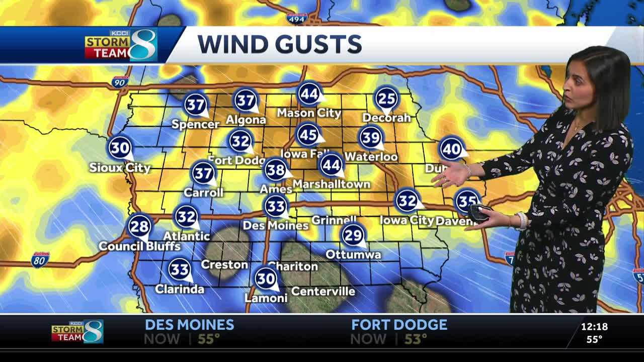
Wind gusts up to 40 to 45mph can be expected for most of Monday, with the strongest winds north of I-80. Temperatures will drop into the mid and upper 40s this morning as the colder air spreads across the state along with the cloudy skies and gusty winds.
Interactive Radar | Weather Alerts
Afternoon highs will only reach the upper 50s to around 60 degrees, nearly 20 degrees cooler than what we saw yesterday. After 3pm, a few spotty showers will start to pop up over far northern and northwest Iowa, then spread into central Iowa by the late afternoon hours. The chance for a spotty shower or isolated thunderstorm should reach the Des Moines metro by 5 or 6pm. Any rain won’t last long and shouldn’t amount to much, but you could run into a brief downpour or two, with the rain drying up by 10pm. Skies should clear out overnight, though the breezy conditions will continue with lows falling into the mid-30s.
Sunny skies return on Tuesday, but the windy weather will continue with northwest wins of 20 to 30mph. Morning temperatures in the 30s will warm back into the upper 50s to around 60 degrees by the afternoon, slightly below average for mid-April. Winds will flip around to the south on Wednesday and stay gusty, but temperatures should warm into the 70s by Wednesday afternoon.
A storm system will move into the Midwest on Thursday bringing rain chances as early as before sunrise on Thursday. Scattered thunderstorms are expected Thursday afternoon, and a few could be on the strong side. Gusty winds will continue on Thursday as well with highs in the 70s. Winds flip back to the northwest on Friday, staying gusty and pulling in more cooler conditions heading into the weekend.
Des Moines Forecast
Today: Clouds early, then sunnier toward midday. A spotty shower or storm after 4pm. High 60F. Winds NW at 15 to 25 mph. Gusts up to 40 mph.
Tonight: Partly cloudy. Windy this evening. Low 36F. Winds NW at 10 to 20 mph. Winds could occasionally gust over 30 mph.
Tomorrow: Sunny skies. High 60F. Winds NW at 15 to 25 mph. Higher wind gusts possible.
Tomorrow Night: A mostly clear sky. Low 37F. Winds ENE at 5 to 10 mph.