
A hot and humid air mass will remain in place Wednesday, setting the stage for strong to severe thunderstorms by Wednesday afternoon and evening, with the greatest threat expected mainly east of the area. Large hail, damaging winds, and even tornadoes will all be possible.Closings | Interactive Radar | Weather Alerts | Skycams There is still some question as to how much these storms will be able to develop while they’re in our viewing area, and if the afternoon round will even fire, or if the storms will wait until the low-level jet kicks in around 7-9 p.m.Storm chances continue Thursday, beginning with strong storms in the morning carrying mainly a damaging wind threat, followed by the potential for another round of strong thunderstorms during the afternoon, especially across southeast Iowa.Conditions improve noticeably by Friday as cooler and drier air settles in, bringing a break from the stormy pattern along with sunshine and more comfortable highs in the 80s. The quieter weather will be short-lived, however, as showers and thunderstorms return Saturday, with the strongest activity most likely across southwest Iowa.By Sunday, drier air moves back in and temperatures cool further, with afternoon highs dropping into the 70s. That cooler pattern is expected to persist into early next week, and while Sunday looks mainly dry, additional rain chances may develop again Monday, with highs staying in the 70s through at least Wednesday.Keep an eye on weather across Iowa with KCCI’s skycamsWeather watchers can keep an eye on conditions by checking our skycam page, which shows aerial views from more than 20 sites across the state.Iowa weather forecast: Today: Mostly sunny and hot. High around 92F. Heat index around 100F. Winds S at 10 to 20 mph.Tonight: Partly cloudy. A low chance of thunderstorms. Low 75F. Winds S at 10 to 20 mph.Tomorrow: Hot and windy. Thunderstorms possible later in the afternoon, then into Wednesday evening. High 91F. Heat index near 100F. Winds SW around 20 mph. Gusts up to 35 mph.Tomorrow Night: Thunderstorms expected. Severe weather possible, especially into eastern Iowa. Low 68F. Winds SW at 10 to 20 mph.
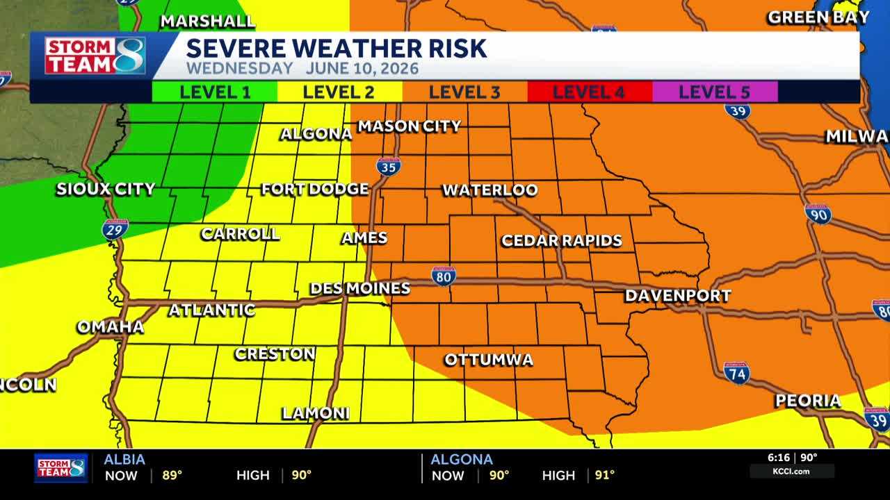
A hot and humid air mass will remain in place Wednesday, setting the stage for strong to severe thunderstorms by Wednesday afternoon and evening, with the greatest threat expected mainly east of the area. Large hail, damaging winds, and even tornadoes will all be possible.
Closings | Interactive Radar | Weather Alerts | Skycams
There is still some question as to how much these storms will be able to develop while they’re in our viewing area, and if the afternoon round will even fire, or if the storms will wait until the low-level jet kicks in around 7-9 p.m.
Storm chances continue Thursday, beginning with strong storms in the morning carrying mainly a damaging wind threat, followed by the potential for another round of strong thunderstorms during the afternoon, especially across southeast Iowa.
Conditions improve noticeably by Friday as cooler and drier air settles in, bringing a break from the stormy pattern along with sunshine and more comfortable highs in the 80s. The quieter weather will be short-lived, however, as showers and thunderstorms return Saturday, with the strongest activity most likely across southwest Iowa.
By Sunday, drier air moves back in and temperatures cool further, with afternoon highs dropping into the 70s. That cooler pattern is expected to persist into early next week, and while Sunday looks mainly dry, additional rain chances may develop again Monday, with highs staying in the 70s through at least Wednesday.
Keep an eye on weather across Iowa with KCCI’s skycams
Weather watchers can keep an eye on conditions by checking our skycam page, which shows aerial views from more than 20 sites across the state.
Iowa weather forecast:
Today: Mostly sunny and hot. High around 92F. Heat index around 100F. Winds S at 10 to 20 mph.
Tonight: Partly cloudy. A low chance of thunderstorms. Low 75F. Winds S at 10 to 20 mph.
Tomorrow: Hot and windy. Thunderstorms possible later in the afternoon, then into Wednesday evening. High 91F. Heat index near 100F. Winds SW around 20 mph. Gusts up to 35 mph.
Tomorrow Night: Thunderstorms expected. Severe weather possible, especially into eastern Iowa. Low 68F. Winds SW at 10 to 20 mph.