
A quiet start to Sunday but multiple rounds of storms and the potential for severe weather is still on the way throughout the weekend and into early next week. Interactive Radar | Weather Alerts | SkycamsSeveral clusters of strong storms rolled through central Iowa last night and early this morning, with multiple reports of large to very large hail across northern portions of the state. We’ll see a brief break in the active weather this morning through the early afternoon with sunny skies making a return. Temperatures will once again warm into the middle and upper 80s with a slow increase in humidity.Another round of storms is possible as early as 5 or 6 p.m. with scattered storm development near and south of I-80 into the early evening. It’s still not certain if we will see storms develop in this timeframe, but if storms do form, they could be severe with large hail and some high winds. Another line of storms may push into the state this evening and overnight from the west, however if the afternoon storms are more intense, this second line becomes less likely. This line of storms will generally bring a risk for high winds as it moves in, but should weaken as it moves into central Iowa by or after Midnight. More heavy rainfall is likely even as the severe risk diminishes overnight.A showers could linger early on Sunday, but more dry weather is expected for most of the daylight hours. Temperatures will start off in the low 60s, and warm back into the low and mid-80s by the afternoon. Winds will be quite strong, even unpleasant at times. Expect steady south winds of 15 to 25mph, and gusts as high as 35 or 40mph at times.An intense line of storms will develop in the evening over parts of Nebraska and South Dakota. These storms will be capable of large hail, damaging winds, and even tornadoes. However, as the line pushes into Iowa, the intensity should slowly decrease. The line should be pushing into central Iowa between 8pm and Midnight. As the storms move toward the I-35 corridor, the severe risk will decrease. Still, a few storms could produce some hail or wind, but the tornado risk will be much lower for central Iowa compared to Nebraska and South Dakota.Some showers may be lingering to start Monday, but once again we should see a break in the rain for the midday hours allowing temperatures to climb back into the mid-80s. One final line of storms is expected Monday afternoon, with the severe potential higher compared to previous days. Large hail, damaging winds, and even a risk for tornadoes will be present with storms as they develop Monday afternoon over western Iowa, and then push east through central portions of the state during the evening hours.The rain clears out for Tuesday with cooler and drier conditions pushing in for the middle of the week. Highs will drop back into the mid-60s for both Tuesday and Wednesday, warming back into the low and mid-70s for Thursday and Friday. Our next rain chance should hold off until at least the end of next week.Keep an eye on weather across Iowa with KCCI’s skycamsWeather watchers can keep an eye on conditions by checking our skycam page, which shows aerial views from more than 20 sites across the state.Des Moines weather forecastToday: Morning sunshine, more clouds later with the possibility of scattered storms developing this afternoon. A few storms may be severe. High 86F. Winds ESE at 10 to 15 mph.Tonight: Scattered storms possible at times overnight. A few storms could be strong to severe. Low 63F. Winds SE at 10 to 15 mph.Tomorrow: Lingering showers possible in the morning, then partly cloudy and windy. High around 84F. Winds S at 20 to 30 mph.Tomorrow Night: Windy with scattered thunderstorms in the evening, then mainly cloudy overnight with thunderstorms likely. A few storms may be severe. Low 65F. Winds S at 20 to 30 mph.
A quiet start to Sunday but multiple rounds of storms and the potential for severe weather is still on the way throughout the weekend and into early next week.
Interactive Radar | Weather Alerts | Skycams
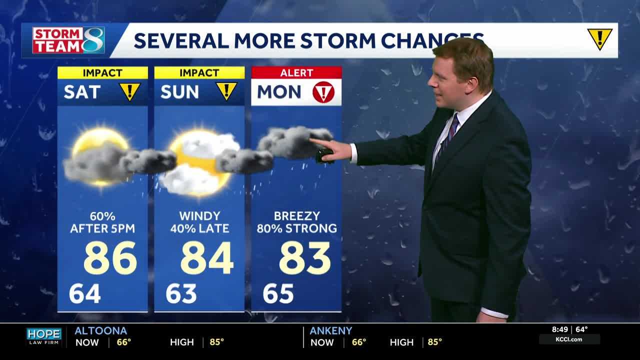
Several clusters of strong storms rolled through central Iowa last night and early this morning, with multiple reports of large to very large hail across northern portions of the state. We’ll see a brief break in the active weather this morning through the early afternoon with sunny skies making a return. Temperatures will once again warm into the middle and upper 80s with a slow increase in humidity.
Another round of storms is possible as early as 5 or 6 p.m. with scattered storm development near and south of I-80 into the early evening. It’s still not certain if we will see storms develop in this timeframe, but if storms do form, they could be severe with large hail and some high winds. Another line of storms may push into the state this evening and overnight from the west, however if the afternoon storms are more intense, this second line becomes less likely. This line of storms will generally bring a risk for high winds as it moves in, but should weaken as it moves into central Iowa by or after Midnight. More heavy rainfall is likely even as the severe risk diminishes overnight.
A showers could linger early on Sunday, but more dry weather is expected for most of the daylight hours. Temperatures will start off in the low 60s, and warm back into the low and mid-80s by the afternoon. Winds will be quite strong, even unpleasant at times. Expect steady south winds of 15 to 25mph, and gusts as high as 35 or 40mph at times.
An intense line of storms will develop in the evening over parts of Nebraska and South Dakota. These storms will be capable of large hail, damaging winds, and even tornadoes. However, as the line pushes into Iowa, the intensity should slowly decrease. The line should be pushing into central Iowa between 8pm and Midnight. As the storms move toward the I-35 corridor, the severe risk will decrease. Still, a few storms could produce some hail or wind, but the tornado risk will be much lower for central Iowa compared to Nebraska and South Dakota.
Some showers may be lingering to start Monday, but once again we should see a break in the rain for the midday hours allowing temperatures to climb back into the mid-80s. One final line of storms is expected Monday afternoon, with the severe potential higher compared to previous days. Large hail, damaging winds, and even a risk for tornadoes will be present with storms as they develop Monday afternoon over western Iowa, and then push east through central portions of the state during the evening hours.
The rain clears out for Tuesday with cooler and drier conditions pushing in for the middle of the week. Highs will drop back into the mid-60s for both Tuesday and Wednesday, warming back into the low and mid-70s for Thursday and Friday. Our next rain chance should hold off until at least the end of next week.
Keep an eye on weather across Iowa with KCCI’s skycams
Weather watchers can keep an eye on conditions by checking our skycam page, which shows aerial views from more than 20 sites across the state.
Des Moines weather forecast
Today: Morning sunshine, more clouds later with the possibility of scattered storms developing this afternoon. A few storms may be severe. High 86F. Winds ESE at 10 to 15 mph.
Tonight: Scattered storms possible at times overnight. A few storms could be strong to severe. Low 63F. Winds SE at 10 to 15 mph.
Tomorrow: Lingering showers possible in the morning, then partly cloudy and windy. High around 84F. Winds S at 20 to 30 mph.
Tomorrow Night: Windy with scattered thunderstorms in the evening, then mainly cloudy overnight with thunderstorms likely. A few storms may be severe. Low 65F. Winds S at 20 to 30 mph.